-40%
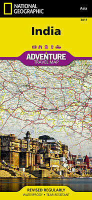
India Adventure Travel Map National Geographic Waterproof
$ 7.37
- Description
- Size Guide
Description
India Adventure Map by National Geographic - Detailed, Waterproof, Rip-ResistantThis map differs from a traditional road map because it includes hundreds of points of interest that highlight diverse and unique recreational, ecological, cultural and historic destinations. NatGeo adventure maps are the perfect companion to a guidebook, yet far easier to pack!
The map includes the locations of cities and towns with a user-friendly index, plus a clearly marked road network complete with distances and designations for major highways, main roads, and tracks and trails for those seeking to explore more remote regions.
The front side of the map covers India's southern half, from the Vindhya Range extending south to the city of Trivandrum. The map also includes the island of Sri Lanka and an inset map of the Andaman and Nicobar Islands in the Bay of Bengal. The reverse side of the map features the northern half of the country, spanning its borders with Pakistan, China, Nepal, Bhutan, Myanmar (Burma) and Bangladesh.
Key Features:
Waterproof and tear-resistant
Detailed topography with clearly labeled natural features
Hundreds of points of interest, including the location of protected sites, parks and nature reserves, protected lands, archaeological sites, wildlife parks, beaches and more
Thousands of place names with a detailed index
Important travel aids including airports, lighthouses, ferry routes and trails
Latitude/Longitude grids along with a compass rose and scale bars for accurate navigation with compass or GPS
Printed two sides on synthetic waterproof tear-resistant material, 25" x 38", folded to a handy 4" x 9".
MSRP .95
Note: watermarked logos on some images do not appear on the map.
